Saskatoon grew up fast along the South Saskatchewan River, and anyone who has broken ground here knows the subsurface doesn't always cooperate. The Meewasin Valley cuts through glacial till, lacustrine clays, and pockets of sand that can vary dramatically within a single city block. Over in the Stonebridge area, developers learned early that what looks like uniform prairie soil can hide abandoned river channels or shale bedrock at wildly different depths. That's where seismic tomography earns its keep. Instead of guessing between boreholes, we map the velocity contrast between loose overburden and competent bedrock, giving you a continuous cross-section that ties the geology together. When borehole data feels sparse, combining it with a CPT test helps calibrate the seismic velocities to actual tip resistance and sleeve friction, so the final ground model reflects real soil behavior rather than just acoustic assumptions.
Seismic tomography turns scattered borehole logs into a continuous subsurface image, cutting the risk of surprises during excavation.
Technical details of the service in Saskatoon
Typical technical challenges in Saskatoon
The NBCC 2020 assigns a site class based on the average shear-wave velocity in the upper 30 meters, and Saskatoon’s variable glacial stratigraphy means you can jump from Class C to Class D or even E within the footprint of a single building. That shift changes the seismic design forces significantly. If you skip the velocity profiling and default to a conservative assumption, you might overbuild the foundation and waste money, or worse, under-design and face liability down the road. A seismic refraction survey gives you measured Vp and derived Vs values that feed directly into the site-specific response spectrum. The City of Saskatoon’s building permit reviewers increasingly expect geophysical data when site conditions are complex, especially for essential facilities and taller structures. Getting the tomography done early avoids redesign loops and keeps the project on the permitting timeline.
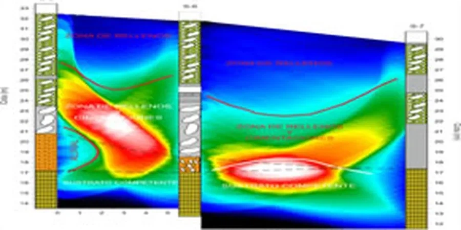
Our services
Our seismic tomography services in Saskatoon cover the full workflow from survey design to interpreted velocity models, adapted to prairie geology and local permitting requirements.
Refraction Tomography for Bedrock Mapping
Designed for sites where depth to bedrock is the main question. We use a 24-channel array with hammer or weight-drop source to map the overburden-bedrock interface across the building pad, delivering a 2D velocity section that complements geotechnical boreholes.
Combined Refraction and MASW for Site Class
When you need both P-wave and S-wave velocity for NBCC site classification, we run refraction tomography and multichannel analysis of surface waves on the same spread. The output includes Vs30 values and a site class letter that you can take straight to the structural engineer.
Top questions
How much does a seismic refraction survey cost for a typical lot in Saskatoon?
For a standard commercial or residential lot in Saskatoon, a seismic refraction survey typically ranges from CA$4,190 to CA$7,600. The final figure depends on the line length, number of shots, and whether you need a combined refraction-plus-MASW dataset for site class determination. We always provide a fixed-price quote after reviewing the site plan and target investigation depth.
What depth can seismic tomography reach in Saskatoon’s glacial soils?
With a sledgehammer source on a 48-meter spread, we reliably image to about 12 to 15 meters depth. Switching to a weight drop or buffalo gun extends that to 40 or 50 meters, which is sufficient for mapping bedrock in most parts of Saskatoon. The actual penetration depends on the velocity contrast between the till and the underlying shale or sandstone.
Does the City of Saskatoon accept seismic tomography for site classification?
Yes. The NBCC 2020 explicitly allows shear-wave velocity measurements for site class determination, and the City’s building permit reviewers accept seismic refraction and MASW data when submitted as part of a geotechnical report stamped by a professional engineer licensed in Saskatchewan.