Saskatoon sits near the northern edge of the Western Canada Sedimentary Basin, where the Precambrian Shield lies roughly 150 km northeast. That deep basement rock transmits earthquake energy efficiently, and although the 2020 magnitude 4.1 event near Kindersley was modest, it reminded engineers that the Prairie provinces are not aseismic. The city's population of 275,000 occupies both sides of the South Saskatchewan River, and the variable thickness of glacial till overlying Cretaceous shale creates sharp contrasts in shear-wave velocity across short distances. A seismic microzonation study maps those contrasts. It moves beyond a single NBCC site class and identifies where deeper soft sediments can amplify ground motion by a factor of two or three relative to adjacent stiffer ground, which matters when designing critical infrastructure, tall buildings, or schools on the east-side floodplain versus the west-side uplands.
The difference between a uniform NBCC site class and a measured microzonation map can be a full design spectral acceleration step, and that step changes the lateral force on a building by 20 to 40 percent.
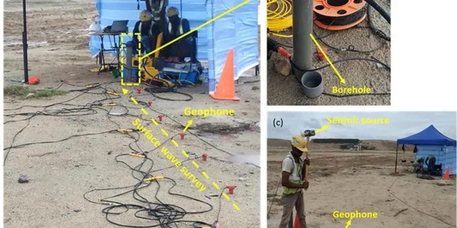
Technical details of the service in Saskatoon
Procedure video
Typical technical challenges in Saskatoon
A five-storey residential building proposed on Avenue H near the riverbank encountered a classic microzonation trap. The geotechnical report assigned Site Class C based on one borehole into stiff till at 12 m depth. A subsequent microzonation survey with MASW lines across the property revealed that the till pinched out beneath the western half of the footprint, replaced by soft glaciolacustrine clay with Vs below 180 m/s, pushing that portion into Site Class E. The structural design had to account for differential spectral demands across the same foundation mat. Ignoring that lateral variation would have under-designed the shear walls on the west side. In Saskatoon, river-adjacent parcels and infill sites on old oxbow deposits carry this risk routinely, and a microzonation study is the only way to map it before the concrete is poured.
Our services
Microzonation in a prairie city like Saskatoon requires more than running a few seismic lines. The work combines surface geophysics, intrusive calibration, and site-specific response modeling. We deliver map-ready spectral ordinates that structural engineers can use directly in ETABS or SAP2000 models.
Vs30 Mapping and Site Class Delineation
Grid-based MASW acquisition along city blocks or entire subdivision parcels, with downhole verification at key boreholes. Each grid node receives a measured Vs30, NEHRP site class, and fundamental period T0 for direct input into the NBCC static or dynamic analysis procedure.
Site Response Analysis and Spectral Matching
One-dimensional equivalent-linear or nonlinear site response using DEEPSOIL or STRATA, calibrated with shear-wave velocity and dynamic soil curves from resonant column testing. Output includes surface response spectra, amplification factors, and time histories for use in performance-based design of hospitals, bridges, and tall buildings.
Top questions
How much does a seismic microzonation study cost for a typical Saskatoon building site?
For a single-building footprint or small subdivision, microzonation studies in the Saskatoon area generally range from CA$5,590 to CA$22,370. The final figure depends on the number of MASW lines, whether downhole calibration in a cased borehole is required, and the complexity of one-dimensional site response modeling. A fixed-price proposal is provided after reviewing the site plan and existing borehole data.
Does Saskatoon really need seismic microzonation given the low seismicity?
The NBCC 2020 assigns a non-zero seismic hazard to Saskatoon, and the city sits on soft glacial lake deposits that amplify long-period motion. The 2020 M4.1 event near Kindersley and the 1982 M5.1 Miramichi event in eastern Canada both demonstrated that intraplate earthquakes can affect stiff soils and soft soils very differently. Microzonation identifies those differences, which directly influence the seismic force level required by the building code for structures with fundamental periods above 0.5 seconds.
What is the difference between a standard site classification borehole and a microzonation survey?
A standard borehole typically provides a single Vs measurement or an SPT N-value correlation, yielding one site class at the drill location. A microzonation survey uses multi-station surface wave arrays or closely spaced downhole tests to map the lateral variation in Vs30 and site period across the entire property. In Saskatoon, where till thickness can change abruptly near the river valley, that lateral mapping catches transitions that a single borehole misses, preventing unsafe averaging of site properties under a large footprint. More info.